Day Trips from Broome: Coconut Well & the Manari Coast
Red pindan cliffs, wild beaches and coastal rock formations — all within an hour or two of Broome. A practical guide to four coastal day-trip destinations on the Manari Road corridor.
The coastline north and west of Broome offers some of the most striking scenery in the Kimberley — red pindan cliffs dropping to turquoise water, wide tidal beaches, and rock formations that change completely with the tide. Coconut Well, Barred Creek, Quondong Point and James Price Point are all reachable as day trips from Broome, though each requires its own planning around tides, road conditions and vehicle type.
These are four separate destinations. You can visit one or combine several depending on your vehicle, the tides and how much time you have. Do not plan to visit all four in a single day without carefully checking distances, road conditions and tide windows in advance.
None of these locations has reliable facilities. Carry your own food, drinking water, sun protection and a first-aid kit. Phone reception is limited or absent at most of these sites. Let someone know your plans before you go.
Coconut Well
Rock pools, a tidal lagoon and a wide coastal beach
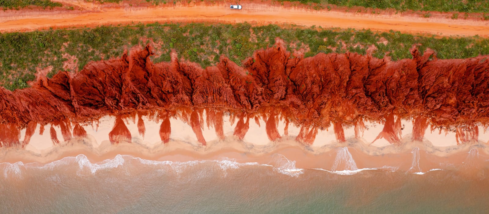
Coconut Well is one of the closest coastal day-trip destinations to Broome — a wide beach with red pindan cliffs, a tidal lagoon and rock pools that are exposed at suitable low tides. The scenery is striking and the location is popular with locals.
Rock pools
At suitable low tides, rock pools are exposed along the beach platform. These offer beautiful coastal scenery and the opportunity to observe marine life in its natural environment. Marine life — including small fish, crabs and invertebrates — may sometimes be seen in the pools. Turtles and other wildlife occasionally visit the area, but sightings are not guaranteed and should not be expected. If you encounter wildlife, observe from a respectful distance. Do not touch, feed, chase, corner or attempt to move any animal. Do not enter the water to approach wildlife. If you find an injured or distressed animal, do not handle it — contact DBCA's wildlife assistance line for current guidance.
Tidal lagoon
Coconut Well also has a tidal lagoon that fills under different tidal conditions to the rock pools. The lagoon and the rock pools are distinct features — they do not necessarily require the same tide to be accessible or interesting. Check tide times before visiting and plan which feature you want to see.
Swimming
Coconut Well is not a patrolled beach. Do not assume the rock pools, lagoon or open beach are safe for swimming. Conditions vary with tide, swell and season. Check current beach safety advice before entering the water.
Access & vehicle
Coconut Well is reached via Gubinge Road heading north from Broome. The main road is sealed for most of the route; the final access to the beach may be unsealed. Check current road conditions before travelling. A conventional 2WD vehicle can generally reach Coconut Well in dry conditions, but confirm this with your hire company if you are in a rental vehicle — hire restrictions vary.
Facilities
Limited. There are basic toilet facilities at Coconut Well, but do not rely on them being operational. No drinking water, no shade structures, no kiosk. Carry everything you need.
Getting there
Head north from Broome on Gubinge Road. Coconut Well is signposted. Follow signs to the public beach access area. Do not drive onto the beach unless you are confident in your vehicle's capability and the conditions — vehicles can become bogged in soft sand.
OWNER REVIEW: Confirm current toilet/facility status at Coconut Well directly with the Shire of Broome before publishing. Confirm whether any permit or access fee applies.
Barred Creek
A sheltered creek mouth and coastal scenery on the Manari Road
Barred Creek is a creek mouth on the Manari Road corridor, set against a backdrop of red pindan cliffs and coastal scrub. The creek and surrounding coastline offer attractive scenery and a sense of remoteness that is hard to find closer to Broome. It is a popular spot with locals and experienced visitors.
What to see
The creek mouth, red cliffs, coastal vegetation and wide tidal beach are the main draws. Wildlife — including birds and occasionally marine life — may be seen in and around the creek. The scenery changes significantly with the tide.
Swimming
Do not swim in or cross the creek without current, site-specific safety information. Creek mouths in the Kimberley can be subject to strong tidal currents, and saltwater crocodiles are present in coastal and estuarine waterways throughout the region. Follow all current signage at the site.
Access & vehicle
Barred Creek is reached via the Manari Road, which turns west off the Cape Leveque Road. The Manari Road is unsealed and corrugated in sections. A 4WD is recommended. Road conditions vary significantly with season and recent weather — check current Shire of Broome road reports before travelling. If you are in a hire vehicle, confirm that your rental agreement permits travel on unsealed roads.
Facilities
No facilities. No toilets, no drinking water, no shade. Carry everything you need.
Getting there
From Broome, head north on the Cape Leveque Road. Turn left onto the Manari Road and follow it west to Barred Creek. The turn-off is signposted. Allow extra time for corrugations and variable road surfaces.
OWNER REVIEW: Confirm current access status and any permit requirements for Barred Creek with the Shire of Broome and relevant land manager before publishing. Confirm whether any areas are on Aboriginal land requiring a permit.
Quondong Point
Coastal rock formations and wide views along the Manari Road
Quondong Point is a coastal headland on the Manari Road, offering views across the Indian Ocean and along the red pindan coastline. The point itself features rock formations and a wide beach. It is a quieter and more remote destination than Coconut Well, and rewards visitors who are prepared for the drive.
What to see
Coastal rock formations, wide ocean views, red cliffs and a wild beach. The area is largely undeveloped. Wildlife — including seabirds and occasionally marine life — may be seen.
Access & vehicle
Reached via the Manari Road (unsealed, corrugated). A 4WD is recommended. Road conditions vary — check current Shire of Broome road reports before travelling. Confirm hire vehicle restrictions if applicable.
Facilities
No facilities. No toilets, no drinking water, no shade. Carry everything you need.
Getting there
Continue along the Manari Road past Barred Creek. Quondong Point is further along the coast. Follow current signage and track markers. Do not attempt the drive in a conventional 2WD vehicle without confirming current road conditions.
OWNER REVIEW: Confirm current access status, any permit requirements, and whether any areas are on Aboriginal land requiring a permit. Confirm preferred spelling with the Shire of Broome or Landgate mapping.
James Price Point
Dramatic red cliffs and coastal views north of Broome
James Price Point is known for its dramatic red pindan cliffs rising directly from the ocean — one of the most photographed coastal landscapes in the Broome region. The cliffs are striking at any time of day, and particularly vivid in the late afternoon light. The site is accessible as a day trip from Broome.
What to see
The red cliffs are the main attraction — sheer pindan walls dropping to the ocean, with wide coastal views north and south. The beach below the cliffs is accessible at low tide in some areas. Seabirds and occasional marine wildlife may be seen from the clifftop.
Access & vehicle
James Price Point is reached via the Cape Leveque Road heading north from Broome, with a turn-off to the coast. The access road to the clifftop viewing area may be unsealed. Check current road conditions before travelling. A conventional 2WD vehicle may be suitable in dry conditions — confirm with your hire company if applicable.
Facilities
Limited. Basic facilities may be present at the main access point, but do not rely on them. No drinking water. Carry everything you need.
Getting there
Head north from Broome on the Cape Leveque Road. The James Price Point turn-off is signposted. Follow the access road to the clifftop viewing area. Do not drive to the base of the cliffs.
OWNER REVIEW: Confirm current access status, any permit requirements, and current facility status at James Price Point with the Shire of Broome before publishing.
Driving and Planning
The Cape Leveque Road heading north from Broome is sealed. The Manari Road, which branches west from the Cape Leveque Road and gives access to Barred Creek and Quondong Point, is unsealed and corrugated. James Price Point and Coconut Well have their own access roads — conditions vary.
A 4WD is recommended for the Manari Road and for any beach driving. A conventional 2WD vehicle may be suitable for Coconut Well and James Price Point in dry conditions, but this depends on recent weather and current road state. Always check before you go.
If you are hiring a vehicle, check your rental agreement carefully. Many standard hire vehicles are not permitted on unsealed roads, and some companies prohibit beach driving entirely. Driving outside your hire agreement may void your insurance.
Allow realistic driving time. Corrugations, soft sand and changing conditions slow progress significantly compared to sealed road speeds. Add buffer time for stops, tide windows and the unexpected.
Tides and Beach Access
Broome has one of the largest tidal ranges in Australia — up to 9 metres. Tides dramatically affect what is accessible at each of these locations: rock pools, creek mouths, beaches and cliff-base areas all change with the tide. Plan your visit around the tide, not the other way around.
Before visiting any of these locations, check the current tide times for Broome. The Bureau of Meteorology publishes official tide predictions for Broome (tide gauge TP004). Allow time to reach your destination before the tide window you are planning for.
Keep your vehicle and your exit route well clear of incoming water at all times. Tides in this region rise quickly and can cut off vehicles parked on beaches or in low-lying areas. Do not park where the tide can reach your vehicle.
None of the beaches at these locations is patrolled. Do not assume any beach, rock pool, lagoon or creek is safe for swimming. Conditions vary with tide, swell, season and the presence of marine wildlife. Follow all current signage.
Camping
These locations are presented as day-trip destinations. Do not assume overnight camping is permitted at any of them. Check current rules directly with the Shire of Broome and the relevant land manager before planning an overnight stay.
Camping rules at coastal locations in the Broome region have changed over time and vary by site. Relying on old blog posts, campsite apps or historical camping practices is not reliable. Contact the Shire of Broome or DBCA for current, authoritative information.
If you want to camp in the area, use authorised campgrounds with current booking systems. The Dampier Peninsula has several established camping options — see our Dampier Peninsula guide for more information.
OWNER REVIEW: Confirm current camping permissions for each location (Coconut Well, Barred Creek, Quondong Point, James Price Point) with the Shire of Broome and relevant land managers before publishing. If a specific prohibition is confirmed for any site, replace the general note with a clear statement. If camping is permitted at any site, add the current booking details.
Wildlife
Marine and coastal wildlife — including turtles, seabirds, fish and invertebrates — may be encountered at these locations. Observe all wildlife from a respectful distance. Do not touch, feed, chase, corner or attempt to move any animal. Do not enter the water to approach wildlife.
Saltwater crocodiles are present in coastal and estuarine waterways throughout the Kimberley, including creek mouths. Follow all current signage. Do not swim in or near creek mouths, estuaries or unfamiliar waterways.
If you find an injured or distressed animal, do not handle it. Contact DBCA's wildlife assistance line for current guidance on who to call.
Items for owner review before publishing
- 1Coconut Well: confirm current facility status (toilets), any access fee, and whether any permit is required.
- 2Barred Creek: confirm current access status, any permit requirements, and whether any areas are on Aboriginal land requiring a permit.
- 3Quondong Point: confirm preferred spelling with Shire of Broome or Landgate mapping. Confirm current access status and any permit requirements.
- 4James Price Point: confirm current access status, any permit requirements, and current facility status.
- 5Camping: confirm current camping permissions for all four locations with the Shire of Broome and relevant land managers.
- 6All distances are approximate and based on standard mapping. Verify against current road routes before publishing.
Planning a day trip from Broome?
Tell us your vehicle type, travel dates and what you're hoping to see. We'll give you honest, practical advice on what's worth the drive.